

Dragon’s Back (Kw’okw’echíwel Stl’áleqem) – HIKES NEAR VANCOUVER
Drag on’s Back (Kw’okw’echíwel Stl’áleqem) – a hiking trail in Hope (Silver Creek), British Columbia
Trail Stats
Closest City: Hope
Park/Land: Crown; traditional territories of the Stz’uminus, S’ólh Téméxw (Stó:lō), Coast Salish and Nłeʔkepmx Tmíxʷ (Nlaka’pamux) First Nations
Dogs Allowed: Yes
Transit-Accessible: No
Camping Allowed: Yes
4 X 4 Needed: No
Class: Half Day
Round Trip Trail Distance in KM: 5.8
Hiking Time in HR: 3-4
Average Grade %:
Cumulative Elevation Gain in M: 437
Highest Point in M: 440
Map and Elevation Profile
See the details on my Strava at
Trail Description
Built by the good folks at Hope Mountain Centre from scratch, this trail was started in 2020, opened in 2021, and as of writing in October 2021, is still being worked on as needed.
The trail is officially named Kw’okw’echíwel Stl’áleqem meaning “Lookout of the Two-Headed Serpent” in Halq’eméylem, which is how the trail builders wish it to be referred as. In English it is commonly referred to as Dragon’s Back.
Archaeological work was done prior to the trail’s construction, indicating the area was originally traversed by Sto:lo hunters and travellers, used as a safety lookout to help guard the villages along the river.
The trail is located in Silver Creek, a neighbourhood just west of Hope proper, in the Skagit Range of the Cascade Mountains.
Fun fact: Silver Creek is my neighbourhood. I see this mountain from my backyard!
The trailhead is off Silverhope Road (see Google Maps here or type in 19255 Silverhope Rd). There is a large gravel parking lot at the end of the small gravel road on your right off this main dirt road. The parking lot and trail are accessible by any motor vehicle as it is a very mellow dirt/gravel road with just a few small potholes.
At the end of the parking lot, you will find this wooden sign post indicating the trail information.

Follow the trail for just a few minutes and off to the right you will find a very long rope swing.

Keep going and you will find another trail sign after just a couple minutes.

The trail undulates with some very steep ups and downs, broken up with a couple of nice flat sections. It is mostly a natural trail, with a few sections of stairs and bridges.

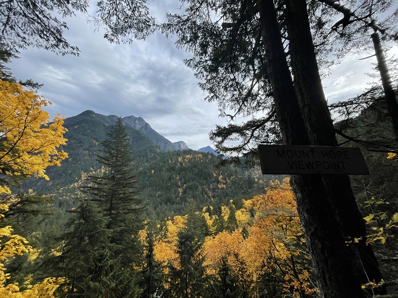
The first viewpoint is of Mount Hope.

Then you reach the Silver Creek Viewpoint.
And then the Stone Garden.
There is only one major junction, giving you a choice to go left or right around the loop.

Going left you will arrive at the West Lookout first, before arriving at the summit.

Either way you go, doing the loop or an out-an-back, is approximately the same distance so may as well do the loop so you get to see it all.
The Summit Viewpoint is the most beautiful of course, as most hike summits are. Arriving from the West, you first see this view looking east over Silver Creek and the town of Hope to the far left.

A few more steps and you’re looking south down the river towards Washington State. This is my favourite viewpoint on the trail.

So many peaks viewable from here. Wells Peak, Mount Grant, Eaton Peak, Silver Peak, Isolillock Peak, and more.

In mid October when I hiked it, the gorgeous Fall colours were radiant. It is very, very steep in some parts. I wouldn’t suggest doing it in winter when there is a lot of snow.
This is beautiful old growth forest so be sure to take your time to admire the incredible ecosystem you are walking through.

At the summit, enjoy the views, take a long break here as the way back is not just downhill.
Always practice all Leave No Trace principles.
There are no amenities anywhere nearby. No outhouse at the trailhead, etc. There is good cell signal the whole way though.
As with every hike, make sure you are prepared. Leave a trip plan and be sure to have all 10 essentials with you! The weather can change on a dime, so be sure to have warm and waterproof gear (learn more about how to stay dry while hiking in this blog post).
Before you head out, downloading an offline trail app like Gaia GPS is a really good idea.
Learn more
Learn more about hiking trails near Vancouver by following us on Instagram.
Source link


